Get the world’s No. 1 choice in marine mapping - with the best, most up-to-date Navionics+ cartography on a compatible chartplotter.
For offshore or inland waters, this all-in-one solution offers detail-rich integrated mapping of coastal waters, lakes, rivers, and more. Get SonarChart™ 1’ (0.5 meters) HD bathymetry maps and advanced features such as dock-to-dock route guidance technology, live mapping, and Plotter Sync to provide wireless access to daily updates.
The Navionics Chart Installer software also ensures the freshest chart data every time. Navionics dock-to-dock route guidance solutions suggest a path to follow through channels, inlets, marina entrances, and more. Multiple shading options aid in shallow-water navigation and make it easy to highlight a target depth range for the best fishing spots.
Navionics Platinum+™ charts include all the content of Navionics®+ cartography, with integrated offshore and inland mapping, 42,000+ lakes and additional viewing options for relief shading, satellite imagery with SonarChart shading overlay, 3D perspective view, aerial photos, and more.
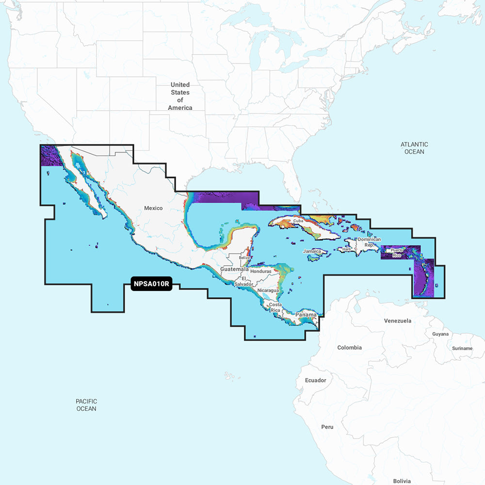
Chart Code: NPSA010R
Coverage Area:
Detailed coverage west coast of Mexico from Tijuana to Panama. Including the Panama Canal in its entirety. East Coast coverage from Panama to Brownsville, TX. Also includes detailed Caribbean coverage of the Far Bahamas, Turks & Caicos, Cuba, Jamaica, the Caymans, Haiti, Dominican Republic, Puerto Rico, and the Lesser Antilles To Grenada.
Features:
Coastal Content - Offers detail-rich integrated mapping of coastal waters, lakes, rivers, and more
Inland Content - 44,000+ lakes
Detailed Nautical Charts - Comprehensive charts are derived from multiple officials, government, and private sources, displayed in a familiar look and feel
SonarChart HD Bathymetry - Innovative 1' (0.5 m) bathymetry charts are created by using Navionics proprietary systems that augment existing content with sonar data contributed by the boating community
Daily Updates - Up to 5,000 daily updates to the charts give the most accurate, most current Navionics data available
Dock-to-dock Route Guidance2 - Start the trip with a suggested path
Plotter Sync1 - Allows compatible chartplotter owners to transfer routes and markers, update chart layers, and more
Community Edits - Get useful local knowledge from edits made by users of the Navionics Boating app on a compatible smart device
Advanced Map Options1 - Customize the view to focus on the details that matter most
SonarChartTM Live Mapping3 - Watch new 1' personal HD bathymetry maps develop in real-time as the boat moves along the water (it appears as an additional layer over the map, while it also gets stored on the device for future use)
High-Resolution Relief Shading1 - Get an easy-to-interpret, clearer view of the bottom structure
Satellite Imagery with SonarChart Shading Overlay - Experience an enhanced awareness above and below the waterline
Sonar Imagery1 - View bottom hardness clearly and in a contrasting color
Aerial Photos - Get a better sense of your surroundings
3D View - Adjust the perspective of your chart view to highlight key features and enhance awareness
Compatibility:
Check the compatibility of Platinum+ content and features with a GPS chartplotter
Technical Specifications:
Format: SD/MSD Card
In the Box:
SD/MSD Card
1Subscription not required for the SonarChart Live mapping feature on some chartplotter models; requires the latest chartplotter firmware release.
2Dock-to-dock Route Guidance is for planning purposes only and does not replace safe navigation operations.
*Sold as an Individual
This product may not be returned to the original point of purchase. Please contact the manufacturer directly with any issues or concerns. Quick Guide (pdf) Brochure (pdf)
We clean up after ourselves.
Ecommerce deliveries have a carbon footprint. That's why we support verified projects that remove carbon from the air.
PARTICIPATING BRANDS AND CUSTOMERS HAVE HELPED FUND
52+million
Carbon-neutral orders
38+thousand
Tonnes of carbon removed
THAT'S LIKE...
4billion
Smartphones charged
159million
Kilometers driven by a gasoline-powered car
HOW IT WORKS
Every delivery’s carbon footprint is calculated based on weight, shipping method, and distance traveled. We neutralize these emissions by purchasing verified carbon removal credits from groundbreaking projects.
MAKING A DIFFERENCE
With your purchase, you’ll join a community of proactive merchants and customers dedicated to a sustainable future. Together, we've removed emissions for over 52 million deliveries and removed over 38 thousand tonnes of carbon.
FUTURE-PROOFING OUR PLANET
We work with a network of pioneering carbon removal companies that have been vetted by the commerce platform Shopify.